Hinderton Lodge
by
Ian L. Norris
Unlike its better known cousin, Hinderton Hall – which still stands on the east side of the Chester High Road (A540) – Hinderton Lodge in Little Neston is now lost to us although, in its day, it was clearly a building of significance. Despite this earlier prominence, Hinderton Lodge remains something of an enigma; we know where it stood, and some of the families who lived there, but no details are known of its date or form of construction and no illustrations or photographs of it are known to the author other than those used in this account.
Where was it?
One of the earliest accurate maps to show Hinderton Lodge was the Ordnance Survey 1-inch map of the mid-1830s (but with some amendments made afterwards), an enlarged extract from which is shown below:  From this map we can see clearly that Hinderton Lodge lay less than half a mile to the east of Neston town centre and on the south side of the road leading from Neston to the road junction at the Hinderton Inn. This road, of course, is Hinderton Road and the Hinderton Inn became the Shrewsbury Arms and, more lately, the Hinderton Arms. Although this map shows us some familiar places, there are many more that we have lost – in the north there was Leighton Hall and Ashfield Hall, to the north-east was the racecourse at Hinderton (with a stand) and in the south the colliery was sited around where present-day Marshlands Road meets the estuary. One notable building absent from this map is Hinderton Hall on the Chester High Road (A540) which wasn’t constructed until 1856; its present-day location has been shown on the map by the green rectangle.
In the early nineteenth century the Neston area was still predominantly agricultural and the individual townships of Great Neston, Little Neston and Ness retained their identity and were separated by agricultural land. Although, as coal mining in Ness and Little Neston had increased in importance, the local population had enlarged (albeit countered, in some measure, by a loss of population following the decline in shipping activity on the Dee), the population of Neston parish was still only 3809 in 1841 when there were 368 houses in Neston. In fact the population actually declined between 1841 and 1851 in which year it was 3578 of which 511 lived in Little Neston. Hinderton Lodge, in the first half of the nineteenth century, was equidistant from Great Neston and Little Neston yet was located in open countryside and with no close neighbours. It was not, however, isolated being set back from one of the main thoroughfares, Hinderton Road, to which it seemingly had access by means of a short driveway:
Although it is difficult to be certain this map also suggests a garden (perhaps with a pond?) between the house and Hinderton Road.  Towards the south the Lodge was connected to Little Neston village by means of a lane – probably little more than a track – the southern section of which, A, now constitutes Mellock Lane. Unlike at the present day, where Mellock Lane continues northwards as Bushell Road to meet Hinderton Road, this lane terminated abruptly with a lane, B, leading from its northern terminus to Hinderton Lodge. Whether or not this lane was a private way to the Lodge, or whether it was a public right of way at this time, is unknown. This section of lane, B, no longer exists as it was approximately the line taken by the rail track when the Birkenhead Railway (a joint railway owned by the Great Western Railway and London and North Western Railway) cut the route from Hooton to Parkgate and which opened on 1 October 1866.
We can now turn our attention to the tithe map which, for the area with which we are concerned, was created about 1849. Drawn to a larger scale than the OS First Edition map, this gives much more detail and gives us, by means of the Tithe Apportionment, the names of the landowners and tenants of each plot of land at that time. From a location point of view, this map is of interest as it does not show the house – whose form is now apparent – as having a direct connection to Hinderton Road from which it is set back just 100 yards. This may represent an error on the tithe map, but it is known that the OS First Edition map, although base-surveyed and published by 1840, was amended to show some minor changes in the 1850s and early 1860s. A tentative conclusion, therefore, is that the tithe map actually predates this OS First Edition map; in 1849 Hinderton Lodge could be reached only from Little Neston village (although, no doubt, there was pedestrian access from Hinderton Road) but a driveway to Hinderton Road was constructed some short time later.
The Lodge, which was of significant size, occupied the land now containing three modern bungalows and their gardens on the south side of Cedar Grove. The section of Cedar Grove leading north to Hinderton Road approximates to the position of the original drive of the Lodge.
When was it built and what was it like?
There appears to be no evidence which allows us to state with any certainty when, or why, Hinderton Lodge was built.
Certainly, Christopher Greenwood’s 1 inch to 1 mile county map of 1819 – predating the tithe map by 30 years – does show a significant building in approximately the correct position although seemingly further south of Hinderton Road than its known location.
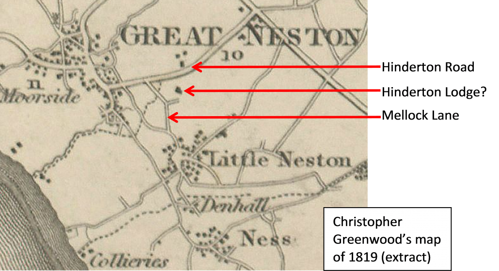 It is interesting also to note the road layout in the vicinity as, on Greenwood’s map, Mellock Lane does continue northwards to meet Hinderton Road in addition to having a westward branch which also meets the road. Another map of this period is A. Bryant’s 1¼ inch to 1 mile county map of 1831 and this is uncontroversial in depicting, and naming, Hinderton Lodge which is set within a green-tinted rectangle.
  Clearly, at this date, the Lodge was considered to be a significant element in the landscape. It is interesting also on this map that the Mellock Lane road layout mirrors that of the 1849 tithe map and not that of Greenwood’s 1819 map. Hinderton Road is named as Chester Lane [the Neston end of Hinderton Road is still called Chester Road]. This map shows also Neston’s second race course, located inland of Parkgate and adjacent to Wood Lane. We can, with certainty, therefore say that Hinderton Lodge existed in 1831 and may have been present in 1819 although any earlier history is unknown to the author. Other evidence which is considered later, however, indicates that it was in existence in March 1825.
 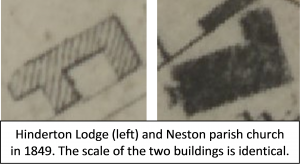 The earliest indication we have of its form is that, on the 1849 tithe map, Hinderton Lodge is shown as an elongated structure with two rear bay extensions, or wings, and this form is confirmed and clarified in more detailed plans of a later date. It is of passing interest to note that the tithe map suggests that Hinderton Lodge and the parish church (this was before the rebuilding of 1875) were, at this time, not dissimilar in area.
We know also from the tithe map, that in 1849 Hinderton Lodge stood on a plot of land with an area of 1 acre 3 roods and 24 perches – almost 2 acres (7690m2).
Whilst we do not know the room-layout of the house an indication of its size is given in the 1911 census which records that the house had 14 rooms (excluding bathrooms and ancillary rooms) compared to the 29 comparable rooms of Hinderton Hall. The 1868 Ordnance Survey map (original scale of 1 inch to 1 mile) shows that Hinderton Lodge was still occupying a semi-isolated position with no other buildings shown in close proximity. Indeed, the house’s connection directly to Little Neston had probably been disrupted by the construction of the single-track Birkenhead Joint Railway (Parkgate Branch) from Hooton which had been opened in 1866 and which, having finally closed in May 1962, became the Wirral Way in 1973. This line, then running only as far as Parkgate, assisted in moving coal from the mining area in Little Neston although mineral sidings giving the line 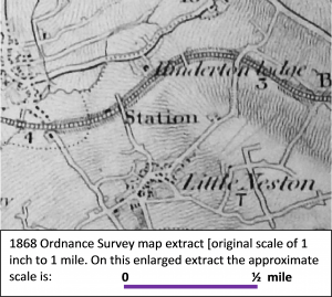 direct access to the collieries do not seem to have been constructed until around nine years later. In the immediate vicinity of Hinderton Lodge the line of the rail track, here in a cutting, paralleled the roadway linking the Lodge to Little Neston. Bushell Road still did not exist at this time, Mellock Lane (from Little Neston) extending only as far northwards as the railway station (which later became Neston South station). Interestingly, the map indicates that Neston did not seem then to have a direct road access to this station.
By the time of the 1881 Ordnance Survey 1:2500 plan (an original scale of about 25 inches to 1 mile) we have a much clearer impression of the Lodge and its surrounding geography and, although the road from Little Neston still terminates just north of the bridge over the railway line, a road (Station Road) now connects the station to Neston. Much more detail is now seen of Hinderton Lodge and its grounds and from this we can get an approximation of the ground plan of the house and its dimensions. From the plan we can estimate that the main body of Hinderton Lodge (excluding the apparent extensions and outbuildings) had a ground floor area of about 3725 square feet (about 253m2). If we presume this was a two-storey house – it is highly unlikely to have been single-storeyed but may, at least in some part, have been three-storeyed – then these figures may be doubled to give the total accommodation of the main house. To put these figures into perspective, a modern (2013 data) two-storey family home in Britain has a total floor area of about 97m2 and Hinderton Lodge would, therefore, have had approximately five times the floor area. Unfortunately, of course, the plan gives us no constructional details of the Lodge – we don’t have any indication of whether it was constructed of brick or of sandstone (there were several active brickworks and quarries in the vicinity at this time so either material could have been used) and we don’t know the architectural style of the building.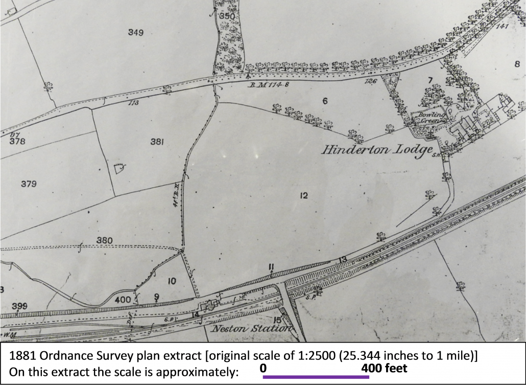
The 1881 plan gives some detail of the gardens, outbuildings and layout of the paths around the Lodge. On the enlarged extract of the plan, below, the features referred to are identified by means of numbers eg and it is possible, using the symbolic representations on the plan, to make some broad assumptions about the overall design of the ground’s landscape. To the rear of the property there was little room for any garden as the house and (presumed) courtyard extended to the path/lane [1] which gave access to Little Neston. It is probable that a wall separated the northern line of this path from the house. A summer house [S.H.2] lay at the elbow of this path, presumably in the corner of the western garden and accessed by the paths [dashed lines] although the actual location of this building is not clear. It appears as if this western garden [3] was a lawn with surrounding paths but, probably, with plants/shrubbery along the southern boundary.
 One of the most interesting features is the presence of the rectangular bowling green [4] one of several in Neston at that time. Between the Lodge and Hinderton Road lay a small area of parkland [5] which, to the west, was defined by a line of trees which led to a triangular area of garden adjoining Hinderton Road. The eastern boundary of this parkland, seemingly paralleled by an avenue of trees, was the driveway [6] to the house from Hinderton Road; this drive swept around the façade of the Lodge and was separated from the parkland and bowling green by an area of shrubbery [7] or flower beds. Lying immediately east of the house there appears to be a walled garden, probably with fruit trees around the walls and vegetable plots within the interior [8]. Another (probably) vegetable and flower garden, with glasshouses [9] lies further east and the small rectangles [10] probably represented cold frames, for raising plants, located against the eastern wall of the walled garden. Although there is no written record of Hinderton Lodge to verify this description, many of the elements of the garden outlined above would have been typical of a large house of this period.
We can compare this 1881 plan with that of the 1:2500 OS plan (drawn to the same original scale) of 1912, some 30 years later. Hinderton Lodge is not now so secluded for, although there has been no residential development on the southern side of this sector of Hinderton Road, a succession of large ‘villas’ set within elongated gardens has appeared bordering the northern side of the road. Indeed, it is known that these houses were existing at the time of the 1911 census – ‘Vizcachani’, shown on the map, was a twelve-roomed house occupied by South American merchant John Lionel Barber (41) and his family and servants. Whilst, overall, Hinderton Lodge and its grounds do not appear to have altered significantly from their representation in 1881, there are some changes which can more easily be identified on an enlargement of this part of the plan. Perhaps the most obvious change is the loss of the bowling green, but it can also be seen that the façade of the Lodge has gained two small extensions and the outhouses, supposed to be glasshouses in the description of the 1881 plan, have been further developed. Less obvious is the change to the western boundary of the garden – this has been pivoted to the west making the frontage of the grounds on Hinderton Road much narrower than in 1881. However, the plan does indicate that the plot of land supporting the Lodge was 2.418 acres, rather more than the 2 acres stated in the tithe map of 1849.
Who lived at Hinderton Lodge?
As we don’t know precisely when Hinderton Lodge was built, we don’t know who was responsible for its construction. In June 1825 a Cheshire Will was proved of Thomas Podmore of Hinderton Lodge and the burial records of Neston parish church (which also names his residence as Hinderton Lodge) shows that he was buried, aged 46, on 17 March 1825. This would appear to be the earliest known reference to the building. In
1849 the tithe map records that the land on which the house stood was owned by John Larden and that the occupier was George White, of whom nothing is known. John Larden, however, was a well-known and influential resident of Neston around this time and in the 1841 census he was recorded, aged 60, as an M.D. living on Parkgate Road with his 50-year old wife, Kezia. In the 1851 census, aged 70 and still living on Parkgate Road, he is recorded as having been born at Malpas and that he was ‘retired, graduate of the University of Edinburgh’. Larden, a doctor of physic (a medical practitioner), was the son of John Larden who was sheriff of Chester in 1785, and mayor in 1801 (and who had married Hannah Edge of Neston), and he was clearly a man of some wealth. It is known that he lived on Parkgate Road in the large three-storey Georgian house now called Moorside House and in 1809 there is a record of him being involved in a land transaction in Little Neston although the parcel of land, recorded then as Little Hay, does not appear under this name on the 1849 tithe map. In 1834 he is recorded again in a land transfer: Draft conveyance of land in Neston, co. Chester between John Baskervyle Glegg of Gayton Hall and also of Old Withington, co. Chester, esq.; John Larden of Great Neston, co. Chester, M.D. and J.F. Maddock of Chester, gent. The tithe map apportionment shows also that John Larden occupied the seven acres of land (which included the fields numbered 136 on the map) and which lay adjacent (north-east) to Hinderton Lodge. Larden did not own this land – it formed part of the Earl of Shrewsbury’s estate – but he was leasing it at this time. John Larden, who had been born 19 October 1780, died on 29 November 1853 and was buried at Neston on 3 December aged 73.
As noted earlier, nothing is known of George White; no death of anyone of this name is recorded locally and he does not appear to have been buried at Neston. The next family we encounter as residing at Hinderton Lodge is that of (William) Arthur Gorst, a cotton broker of Liverpool, who had been born in New Ferry around September 1837. In the census of 1881, aged 43, he is recorded at the Lodge with his wife (Elizabeth Ann, 43, born Liverpool), four daughters and a son. The youngest daughter, Edith Charlotte (5) had been born in Thornton Hough and Henry Percy (2) was born in Neston. In addition to the family there were four servants in the household. It appears probable that the Gorsts were not at Hinderton Lodge when Elizabeth was born in July / September 1875 but they were recorded as being there when George Ruddle, Arthur’s uncle, died there on 29 August 1878 whilst he was visiting the family.
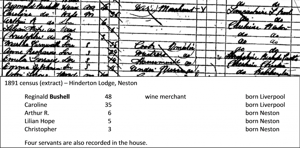 By the time of the 1891 census the Gorst family had moved from Neston (although some relatives remained in the town) and were living in Claughton, Birkenhead and wine merchant Reginald Bushell and his family had moved to Hinderton Lodge: Reginald Bushell was the eldest child of Liverpool wine merchant Christopher and Margaret Bushell and the family, including Reginald, had lived at Hinderton Hall since the house was built for them in 1856. Reginald worked as a partner in the family business, Bushell Brothers and Co, Wine Merchants and Shippers of Castle Street, Liverpool and he appears to have lived with his parents and many siblings at Hinderton Hall until he married Caroline Hope in Kensington in April / June 1883. Arthur Reginald, their first child, was baptised at Neston on 29 August 1884. Lilian Hope Bushell was baptised at Neston on 4 September 1885; Reginald was then described as being a merchant and their address was recorded as Oakhill, Neston, suggesting that they had not yet moved to Hinderton Lodge. Christopher, their third and last child, was born on 31 October 1887 and Reginald and Caroline were certainly living at Hinderton Lodge at this time; it appears, therefore, that they had moved there in the previous two years.
Christopher Bushell was killed in action on the Somme on 8 August 1918 having earlier been awarded both the Distinguished Service Order and the Victoria Cross. Reginald and his family were still at Hinderton Lodge ten years later, at the time of the 1901 census, although Christopher was away from home at a Boarding School in Heswall.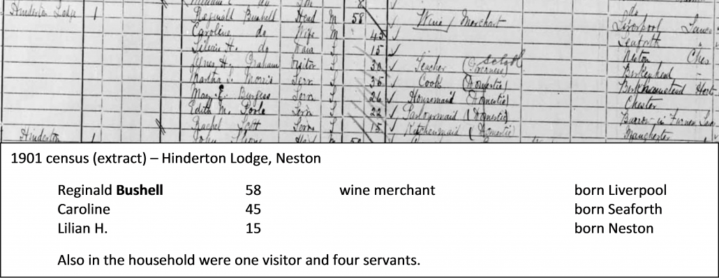 Reginald Bushell died at Hinderton Lodge on 11 November 1904, aged 62, and was buried at the parish church on 15 November. Following Reginald’s death the family moved from Neston, probably sometime after 1910, to their London property, 59 Kensington Court, Knightsbridge and Caroline bought a second house near Dover.
Reginald was a keen meteorologist and after his death it was recorded that Mr Reginald Bushell, of Hinderton, Neston, was responsible for the oldest record in the Wirral peninsula, he having carried it on from 1869 to 1903, and we are happy to know that it is still being kept up, as Miss Bushell has taken her father’s place. Reginald’s daughter, Lilian, maintained the meteorological station at Hinderton Lodge until 1908 when it was recorded that:  In Cheshire we regret the loss of the two gauges at Hinderton ; but we are grateful that they have been continued so long, as a less keen Observer than Miss Bushell would very probably have allowed them to drop several years ago, and she has arranged for keeping up the record at Hinderton Lodge.
Following the departure of Caroline and Lilian Bushell from Hinderton Lodge in, or shortly after, 1908 the house was occupied by cotton merchant Edwin Ramsay Moodie and his family and they were there at the time of the 1911 census. Although the house is unnamed on the census form Kelly’s Directory of Cheshire [1914] records Edwin Ramsay Moody living at Hinderton Lodge and it is most probable that this is where he resided in 1911. Edwin, born in 1867, was the eldest son of Edwin Ramsay and Ellen Moodie of Rock Lane, Higher Bebington. Edwin snr was, in the 1881 census, described as Principal Officer, Board of Trade, Liverpool and Ellen (recorded also as Helen) had been born in the USA. In fact it is known that Ellen (née Warriner) was born in Pittsfield, Massachusetts and that she was the daughter of a cotton merchant. Little is known of Edwin jnr although it is known that he was educated at Beaumaris Grammar School, Anglesey, and that he married Helen Agatha Cripps of Seething Wells (part of Surbiton), Surrey, at St Margaret’s, Westminster, on 18 June 1902. Margaret was a daughter of solicitor Henry L. Cripps and her mother, Margaret Pinnington Cripps, was recorded in the household in Neston in 1911. Before his marriage a US City Directory in 1902 listed Edwin, and his brother Ralph, as living at 1203 Union Avenue, Memphis; Edwin was then recorded as being a Manager for the firm of Wm. Watson & Co.
Whilst having been married for only eight years, it is apparent that Edwin and Helen had already travelled before coming to Neston and their son, Robin, had been born in Tennessee, suggesting that Edwin was still actively involved in cotton production in the USA: At the time of the 1911 census Edwin had not long since left a partnership of international cotton merchants and established new companies with a different partner. It is believed that Edwin and Helen had no further children and it is known that Edwin died in Horsham, Surrey, in 1954 aged 86 and that Helen died in south-east Surrey in early 1967 aged 88. It is worth noting also that Edwin’s slightly-younger brother, Ralph Troup Moodie, was a cotton buyer working for Wilson & Moodie (and another brother, Robert, also worked for this company) and that he lived in the USA for most of the year but annually visited his mother and aunt’s home in Hoylake arriving in May and returning to the USA in August.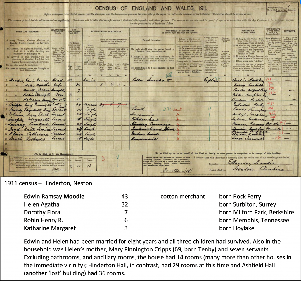
Ralph had been a passenger on the Lusitania in September 1911, August 1913, and September 1914 and was on the ship when it set sail from New York bound for Liverpool on 1 May 1915. Despite warnings against travelling on the Lusitania by the German Embassy in New York, Ralph was taking his annual trip to England at this time and was on board in cabin A26 when the ship was struck by torpedoes from a German submarine off the Old Head of Kinsale, Ireland, on 7 May. Ralph Moodie was one of the 1153 passengers and crew who perished as the vessel sank; it was reported that he had given his lifejacket to a female passenger who, unfortunately, also did not survive. Just to complete the picture of this family, Edwin’s sister, Flora (Ralph’s twin), married Sir Lee Oliver Fitzmaurice Stack GBE, CMG (1868-1924) on 7 October 1902 at St Hildeburgh, Hoylake. He was a British army officer who was the Governor-General of Anglo-Egyptian Sudan and he was assassinated on 19 November 1924 whilst driving through Cairo. Robin Henry Ramsay Moodie, the only son of Edwin Ramsay Moodie, became a Commander in the Royal Navy and he married Rosemary Evelyn Anne Laurie, daughter of Maj.-Gen. Sir John Emilius Laurie in January 1949.He died in 1994.
Dorothy Flora Moodie, Edwin’s eldest daughter, married Vivian L Windus in Guildford, Surrey, in early 1930 although nothing further is known of her. Katharine Margaret Moodie, Edwin’s youngest child, married Ralph Kauntze in Westminster in late 1935. Ralph Kauntze, the son of a Lancashire cotton merchant, was a physician at Guy’s Hospital and was educated at Canford School and Emmanuel College, Cambridge. In 1939 he joined the Royal Army Medical Corps. He served chiefly in the Mediterranean, was an officer in charge of a medical division, achieved the rank of lieutenant colonel and was awarded the MBE in 1944.
In 1945 he returned to civilian life and for two years he was assistant to the director of the department of medicine at Guy’s. [ Further details of the family, particularly Ralph Troup Moodie, can be read on: https://grangehill1922.wordpress.com/tag/edwin-ramsay-moodie/ and http://www.findagrave.com/cgi-bin/fg.cgi?page=gr&GRid=53142126 ] It is not clear when the Moodie family left Hinderton Lodge but The British Bee Journal of 11 April 1918 carried an advertisement: WANTED, two good Stocks, one Queen, early swarms— NICKSON, Hinderton Lodge, Neston. This was Richard W. Nickson and it is known that members of the Nickson family remained at Hinderton Lodge until at least early 1945. The 1911 census recorded that the Nickson family were living at 2, The Oatlands, West Kirby – a substantial three-storey red-brick semi-detached house with twelve rooms in a leafy street off Village Road.
The family then consisted of:
Richard Wigley Nickson 42 provision and general product born Waterloo, Lancs.
(foodstuffs) merchant
Mary Hilda 44 born Liverpool
John Edgar 11 born Hoylake
Geoffrey Wigley 9 born Hoylake
Richard Scholefield 3 born West Kirby
In addition to the family there was a nurse, a governor, a cook and two maids. Richard and Mary had been married for 13 years and all three of their children had survived. Ten years previously, at the time of the 1901 census, the Nicksons were living at 56, Grosvenor Road, Hoylake. It is believed they had no further children.
Richard Wigley Nickson, born in 1868, was the son of grocer/produce merchant John and Isabella Nickson who, in 1891, were living at Cadogan House, Frodsham. Richard married Mary Hilda Margaret Scholefield in West Derby, Liverpool, in early 1898 and he died at Hinderton Lodge on 2 January 1945 aged 77 and was buried at Tal-y-Cafn, a small settlement in the former civil parish of Caerhun on the west bank of the River Conwy, on 5 January. It is possible that Richard and Mary had moved from Neston to Tal-y-Cafn and it is known that Mary died in Tal-y-Cafn in 1940 aged 73. However George Nickson, Richard’s elder brother, is recorded in the 1911 census as living with his family at Gorswen, Tal-y Cafn – he was the Bishop Designate of Southwaite – and it is possible that Richard and Mary had a strong connection to the village but were not resident there.
Certainly, Hinderton Lodge remained the home of Richard’s eldest son John (Jack) Edgar Nickson; it is recorded that he was a Major and, whilst giving Hinderton Lodge as his address, applied several times between 1933 and 1938 for shooting and fishing rights in North Wales. Richard Wigley Nickson died at Hinderton Lodge in early 1945 although it is not clear whether he was then living there or whether he was on a visit to his son. However, the Directory of Directors for 1936 records his address as being Hinderton Lodge at that time and notes that he was then the chairman of George & John Nickson & Co. Ltd.
George & John Nickson (Liverpool) & Co. is listed in Slater’s Directories for 1888-91 under the heading of sugar refiners & sugarbakers, the named owner being George Nickson. The company, at that time, had its business address at 28, Corn Exchange Chambers, Hanging Ditch, Manchester, in 1896 it underwent reorganisation and by 1908 it had broadened its commercial base and had become a company of some significance.
 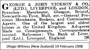 |
Although there is little information for this company it was quite possibly formed by John Nickson, Richard’s father, and John’s uncle George both of whom originated from Stafford. In the 1861 census John, then 23 and recorded as being a commercial traveller and unmarried, was living with wholesale grocer George Nickson (42) and his wife Mary at 16 Canterbury Street, Everton. Although this street has since been redeveloped the house was recorded in the 1911 census as having ten rooms, excluding bathrooms. Unfortunately, it has not proved possible to track George and Mary in later census returns.
Until his death in June 1931 a George Nickson of Caldy – not the founder of the company, to whom his relationship is unclear – was the chairman and it was on his death that Richard Wigley Nickson of Hinderton Lodge presumably took over the chairmanship. In November 1937 the Belfast Gazette, in a schedule of traders, listed George & John Nickson & Co. Ltd. as trading in ‘groceries, preserves and provisions’ and gave the trading address as 25 Victoria Street, Liverpool. The company continued to exist until 1980 when, then described as meat canners and with a registered address at 28 Queen Anne’s Gate, London, it was liquidated in October.
1945 – and beyond
The last reference to Hinderton Lodge known to the author is January 1945 when Richard Wigley Nickson, the last known owner, died there in January. Whilst Richard’s son, Major John (Jack) Edgar Nickson probably lived at the Lodge after his father’s death, no record is known of the house’s occupancy after early 1945.
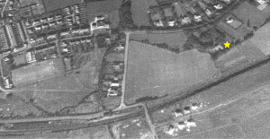
A rather grainy aerial image of the area around Hinderton Lodge, supposedly from 1945, shows the house and the woodland between it and Hinderton Road. Unfortunately, the quality of the image does not allow any detail of the Lodge [indicated by the yellow star on the photograph] to be discerned but it does show that, even at this late date, it stood within fields which separated it from other houses, its closest neighbours being the ‘villas’ to the north of Hinderton Road. Indeed, the fields west of Hinderton Lodge were not developed for housing until the 64 houses of The Quillet were built shortly after 1960 and in that decade, and the 1970s, extensive development took place in Neston as its significance as a dormitory town for Merseyside increased.
It is interesting, to complete the picture, to superimpose the pre-1960 roads on this part of Neston and to conclude by seeing how residential development has encroached onto the previously ‘empty lands’ of this part of the town:
 |
 As commented on above, the author has no knowledge of Hinderton Lodge after early 1945 but he suspects that it remained until, perhaps, the early 1960s when it was demolished to make way for new housing. But does anyone know differently and who were the last residents? Certainly, its demise must have occurred within the (early) lifetime of some of our older residents and some may have stories and memories (and photographs of the Lodge?) that they would be willing to share with us.
Acknowledgements
Ordnance Survey maps & plans (extracts) – Explorer House, Adanac Drive, Southampton , SO16 0AS
Google Earth & Google Maps (UK) – for the aerial views used in this account
UK census data – from https://www.thegenealogist.co.uk (a subscription service)
Other acknowledgements are recorded in the text
Ian L. Norris October 2015


